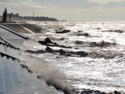
Storms, sea coming over and flooding are all part and parcel of life at the coast. We are very fortunate on the Fylde Coast that we have well maintained and robust sea defences. Although the defences protect us to a good standard, they can never truly prevent any breaching from happening.
Two Recent, Really Bad Storms
Statistics are funny things. They tell us about the chance of something happening – which is based on likelihood – not on fact! A ‘1 in 200 year storm’ is the type of severity which you don’t see very often at all. But that doesn’t mean you’ll only see one storm like this in 200 years… Which is just what happened over the Christmas period in 2013/14 – two severe storms in a matter of a couple of weeks!
1 in 200 Year Storm One: December 2013
On 5/6 December 2013, severe storm conditions affected the whole of the UK. The East coast got the worst of the storm surges.
The Environment Agency issued Flood Alerts as usual, covering the area from Fleetwood to Blackpool. With flood gates closed and precautions taken, everyone waited for high tide at midnight and noon.
The wind started to get up at 5am on Thursday 5 December. By mid morning that day it was clear that there would be a problem at high tide at 12.20pm. To make matters worse, it was also a high spring tide of 9.9m.
You could call it a perfect storm, with a combination of a high tide, a strong westerly wind blowing the sea to shore and low pressure systems. These three factors combine to create high waves, high water and flooding.
First, the foam flies…
By 11am the foam was flying here at Cleveleys, the road covering with a deep mass of quivering jelly. Sea foam is a result of decaying algae in the seawater. With the water agitated into a froth, the alginate holds the bubbles.
FREE Newsletter
FREE Newsletter


By 11.30am, waves were coming over the top of the new sea defences in front of Jubilee Leisure Park, and over the sea wall at Rossall Beach. The promenade and car park at Jubilee Leisure Park were all completely flooded.
Waves coming over the wall
It was so bad that by noon, North and Rossall Promenade were waist deep in foam and waves were coming over the top of the sea wall. They were reaching 15-20′ in height as the tops of them blew onto the houses and road. Take a look at this video clip

The force of the wind was easily 50mph+. So although high tide was at 12.20, the overtopping effects continued until about 1pm.


The sea water coming over the wall turned Rossall and North Promenade into a river, which flowed (as water does) to the lowest point. Which is straight into the lower lying garages of the seafront properties, and straight down the streets off, heading inland. Carrying, of course, all the foam and rubbish with it.

At Anchorsholme at the south end of Cleveleys, waves were well in excess of the height of the old brick wall against Anchorsholme Park as you can see in the next photo. The photo shows exactly why the promenade at Princes Way was rebuilt. Although waves still bash up and over, the increased height and different design has dramatically reduced overtopping.

1 in 200 Year Storm Two: Sea Coming Over and Flooding – January 2014
Our understanding here at Visit Cleveleys is that the storm of December 2013 was a one-in-200-year storm. That is to say the sort of severity that typically only happens once in every 200 years.
But just as buses always come along together, probability doesn’t mean that you can’t have two bad storms back-to-back. This was proved with round two of the bad storms, on 3 January 2014.


The Debris left by Storms, Sea Coming Over and Flooding
This kind of weather is dangerous to go out in. You’re advised to keep away from the seafront, and the worst affected roads usually closed by the council and/or police. It’s not safe to go out hunting for photos in this kind of weather. So we rely on what we’re told – and the evidence afterwards.
But the tide always retreats and the storm always passes. Which leaves the devastation laid bare for everyone to see – and clean up! Water is incredibly heavy – 1 cubic centimetre weighs 1 gram – so just imagine how heavy a bucket of water is. Add extreme force to the weight and you can see why it can cause so much damage. Which is just what happened here – with metal bent and concrete furniture tossed about as if light as a feather.


The sea was coming over along the wall along the length of the sea defences, causing considerable flooding. Local sources told us that the flood water reached as far inland as the tram tracks. Thornton Gate in Cleveleys and the roads at the Anchorsholme end of town were all covered with flood water.
What a mess at Rossall Promenade!
The northern end of Rossall Promenade is a popular seafront parking area – but not now! During the storm it became submerged beneath sea water – which drained away to leave a whole lot of debris behind!


Strengthening the Beach
The next photo was taken during the clear-up process. It doesn’t look that bad, until you consider that the sea doesn’t normally come anywhere near to the low sea wall, never mind over the top of it.
Rossall Beach at Cleveleys is considered to be one of the best protected areas on the Wyre coastline. The curving, natural, sloping shingle beach and slight inward curve of the coastline gives good resilience against high seas. Which just shows how bad this storm was.
However, there’s nothing holding the beach material in place – it builds up and erodes entirely naturally. Which means that successive storms can erode enough beach material to enable serious flooding or even undermining and collapse of the sea wall.
It’s exactly why the Wyre Beach Management Scheme began in 2023, to stabilise the beach and prevent that from happening.

Storms in the Past
Carrie Dennison lived on Thornton Gate in Cleveleys during the floods of 1977. Her dad took these photos at the time.
Carrie tells us “I remember that even though we lived on Thornton Gate, our house didn’t actually flood, and talking to my Dad about it, he thinks there must be a slight rise in the ground around our old house and the South Avenue area. As you’ll see from one of the photos, there was no water on South Avenue until you got to the Queens Walk end. We lived just about opposite Hylda Baker’s old house. I remember Green Drive was flooded too, so we were just in the right spot!”


Earlier Flooding which led to Erosion
We mentioned the possibility of erosion of the sea wall if beach levels were to drop too far. It’s not an urban myth, or scaremongering! It really can happen – and has happened in the past – as you can see in these old photos.

Here’s a later incident when the sea wall collapsed in 1947. There’s a full article here about building the sea wall in 1947.


You might also be interested in…
- Ironically, it was 3 January in 2018 when Storm Eleanor hit the Fylde Coast. But it was no match for the new Rossall Coastal Defence Scheme.
- There’s much more about Sunken Forests here
- The lost village of Singleton Thorpe here
- Plus a piece of research about rising sea levels and whether they’re fact or folklore
While you’re here…
Go to the homepage of the Visit Cleveleys website for the latest updates.
Enjoyed this article? Sign up for your email newsletter. Packed full of interesting things just like this it arrives in your inbox all 52 weeks of the year.
👉Join us on Facebook at our Visit Fylde Coast Facebook Group. Plus hundreds of videos to watch on our YouTube channel – from all over the Fylde Coast!
📣JOIN our new VFC WhatsApp Channel for what’s happening, interesting local information, history, communities, events and much more.
Booking a stay? Pick a safe, clean and legal place to stay, at the very best price. Book with the Visit Fylde Coast guide.

We Need Your Help
We Need Your Help