

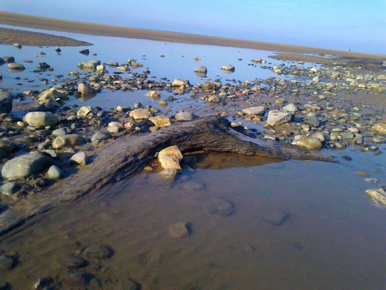
Anyone who’s interested in the local area will no doubt have heard about petrified forests and lost villages. But are rising sea levels Fact or Folklore? Above photo: Andy Ball
Visit Cleveleys has previously covered the sunken village of Singleton Thorpe and the offshore petrified forest. You probably also know that debate on the subject has raged for years. Are the tales of Singleton Thorpe right or wrong?
Then, we were presented with the opportunity to commission some proper research, carried out by a masters student. Maybe we can find out the truth for once and for all?

Research into Fact and Folklore
Immogen Lyons was studying at Lancaster University for her masters degree in Environment and Development. She’d previously completed undergraduate studies in Archaeology at the University of Manchester. Immogen wanted to undertake an environmental masters because she’s passionate about the environment and wanted to change her career prospects. After achieving her masters degree she would like to find a career in the environment sector.
Immogen spent the summer of 2019 researching what might have happened to the shoreline at Cleveleys. Her dissertation is fascinating, revealing new information about our shoreline.
We’ve published highlights of it for you below. There’s also a link for you to download and read the work in full.
Please note that it is copyrighted to Immogen Lyons/Visit Cleveleys. None of it should be reproduced in whole or in part unless permission is sought beforehand from Visit Cleveleys.
FREE Newsletter
FREE Newsletter

Rising Sea Levels – Fact and Folklore
by Immogen Lyons Lancaster University Lancaster LA1 4YQ UK
Submitted September 2019
This Dissertation is submitted in partial fulfilment of the degree of MSc Environment and Development
Abstract
This dissertation was commissioned by Visit Fylde Coast/ the Rabbit Patch Ltd.
It addresses a lost 16th century village on Rossall Beach, Cleveleys, called Singleton Thorpe. It examines geological and historical reports, 19th century literature and archaeological remains, in order to find out if Singleton Thorpe was real, what it looked like and what it was destroyed by. Within the literature it’s said that Singleton Thorpe was destroyed by the sea. The description of the event led people to believe that it was a tsunami.
This dissertation has examined the likelihood of Singleton Thorpe being destroyed by a tsunami, a storm and a bog burst. However there is a lack of evidence of a tsunami and a bog burst. So it’s come to the conclusion that it must have been a storm surge that destroyed Singleton Thorpe (Schillereff et al, 2019).
How many houses make a village?
It has also provided evidence, such as how the Fylde coast was sparsely populated up until the 1800s. This could suggest Singleton Thorpe was smaller than a village. Therefore it could have been a farmstead (Natural England, 2014).
The archaeological remains found on Rossall Beach, Cleveleys, have not been radiocarbon dated or fully excavated. Therefore, more work needs to be done in order to ascertain if these are the remains of Singleton Thorpe. Although, this dissertation has shown how the remains share some architectural features with other examples of medieval buildings. Therefore, it is possible that the remains are from the medieval period and that they are related to Singleton Thorpe.
Introduction
The aims of this dissertation are:
- to find out if Singleton Thorpe was real,
- what this settlement was like
- and what it was destroyed by.
If we were to travel back in time to 1554, we would apparently find a village called Singleton Thorpe that was situated a mile further out than today’s coastline, on Rossall Beach, Cleveleys (Visit Cleveleys, 2019). However, it would not be standing there for much longer, as according to a number of 19th century authors, a “sudden irruption of the sea” destroyed Singleton Thorpe, forcing the survivors to move inland to Singleton (Whittle, 1831: Thornber, 1837).
There is an absence of published material regarding Singleton Thorpe, other than the 19th century authors who briefly mention what happened to this village. Wyre archaeology have also investigated this site but they have not generated a full report on this settlement. This dissertation shall compile all the possible information regarding Singleton Thorpe. We’ll evaluate the information in order to give a comprehensive summary of relevant evidence and recommendations.
Back in Time
Prior to the 17th century timber longhouses were abundant in the Fylde area. This may be the type of structure that Singleton Thorpe was (English Heritage, 2006). Due to the wet environment of the Fylde coast, the remains will probably not have decayed (Blanchette, 2000). Therefore, this dissertation will look at medieval architecture to see if the remains found reflect the architecture of the 16th century (Blanchette, 2000).
In addition to investigating Singleton Thorpe, we’ll highlight how sea levels have changed over time. With a specific focus on the North West of England and the Fylde coast. But there aren’t many sea level reconstructions from the 1st century AD up to the 19th century in the literature. There’s a general focus on sea levels up to 0 BC and then from the 1800s to 2000s.
Singleton Thorpe was thought to have been washed away by a tsunami. So this dissertation will review the possibility of a tsunami being generated in the Irish Sea during the 16th century. We’ll also review other drivers of coastal change, such as storms and how they would have affected Singleton Thorpe. Other factors like bog bursts will be investigated. This will allow us to evaluate the likelihood of a bog burst being responsible for the disappearance of Singleton Thorpe.
Examining the Literature
In order to provide a detailed study of Singleton Thorpe numerous sources have been used. A number of 19th century books and articles have been referenced, as this is the first time Singleton Thorpe is mentioned in the literature. The original document that Singleton Thorpe was actually first mentioned in, and what the later authors quote, has unfortunately remained elusive. However, the use of other documents and resources have made up for its elusiveness. There’s a focus on literature that is closer to the time of Singleton Thorpe. But other resources that include current studies of natural hazards and geology are also used.
- Join us on WhatsApp – for fresh updates, straight to you. What’s happening, interesting local information, history, communities, events and much more.
Contents
- Introduction
- Chapter 1: A Brief History of the North West of England and an Estimation of Past Sea Levels
Starts off with the historical background of the North West of England. This provides a history from the Late Upper Palaeolithic to the Medieval times, in order find evidence of coastal settlements through time. There will also be an estimation of what the sea levels were like during each period. This is to show how sea levels have changed. - Chapter 2: Geological Background
Analyses the geology of the Fylde coast in order to find any evidence for tsunamis, storms or bog bursts. - Chapter 3: Literary Evidence of Singleton Thorpe
Starts to investigate the presence of Singleton Thorpe in the literature and evaluates the reliability of certain sources. - Chapter 4: Archaeological Evidence of Singleton Thorpe
Investigates the archaeological evidence for Singleton Thorpe, which includes an analysis of medieval architecture. - Chapter 5: Was Singleton Thorpe Destroyed by a Tsunami?
- Chapter 6: Or was it Destroyed by a Storm?
Examining the available evidence - Chapter 7: Could Singleton Thorpe have been Destroyed by a Bog Burst?
Could any of these events have destroyed Singleton Thorpe? - Chapter 8: Discussion
Looking at the evidence found within this dissertation, and recommendations for future work. - Conclusion
- Bibliography
- Appendix
Read the Work – Rising Sea Levels – Fact and Folklore
At 51 pages it’s not War and Peace. But it’s fascinating to read, enjoy it with your feet up and a cup of tea.
It begins in the Palaeolithic period, 2.4 million years ago, through to 10,000 BC. This work examines evidence of how the shoreline of the Fylde Coast has changed through the centuries.
Together with radiocarbon dating evidence, the research shows rapid sea level rise in a relatively short period of time. Between 7000 (when it was possible to walk to the Isle of Man) and 6680 BC.
Immogen takes us through centuries of evidence of the Iron Age, Roman occupation and medieval times. Looking at finds, geology and written evidence.
It’s a fascinating read, well written in a logical, sensible sequence that pieces together so many different sources of information. Illustrations, maps and photos are used throughout.
Click on the image to download and read the work –

Conclusion
This dissertation has shown that there was a fall in sea level on the Fylde coast. Levels were lower between the creation of the petrified forest (7040-6680 cal BC), and the 2nd century AD (Eadie, 2012: Ashton, 1920).
It’s also highlighted that the Fylde coast was sparsely populated up until the 1800s. This was partly due to a high frequency of storms and low agricultural potential (Valentine, 2013: Natural England, 2014).
The remains on Rossall Beach have been compared with other examples of medieval architecture. This dissertation has shown that the remains on Rossall Beach have some aspects of medieval architecture. Including lime walls, a timber frame and stone foundations (Allan et al, 2015: Hanawalt, 1986).
This piece of research has also shown how it’s highly unlikely that a tsunami destroyed Singleton Thorpe. Rather, it was most likely destroyed by a storm surge (Schillereff et al, 2019). This is because there is a lack of mention of tsunami deposits in geological reports.
The sites of Waddum Thorpe and Kilgrimol were also not destroyed under the same circumstances or at the same time as Singleton Thorpe (Porter, 1876: Thornber, 1837).
Acknowledgements
I would like to thank my supervisor, Dr Suzana Ilic, for her guidance and support throughout this project. I’d also like to thank Jane from the Rabbit Patch Ltd for commissioning and helping with this industry project.
What’s Next?
Visit Cleveleys will hopefully secure further research by future Lancaster University students. They might look at the wider topic of changing sea levels, coastal erosion and the possible future impact. Watch this space!
Meanwhile, you might also be interested in Coast Watchers. So many coastal processes are at play every day on our shores. With the help of our partners at Wyre Council we’re trying to gather everything together in one place. Added to that will be your photos, recording the shoreline and how it changes.
You never know, in a few hundred years our descendants might be using it for research too!
While you’re here…
Go to the homepage of the Visit Cleveleys website for the latest updates.
Enjoyed this article? Sign up for your email newsletter. Packed full of interesting things just like this it arrives in your inbox all 52 weeks of the year.
👉Join us on Facebook at our Visit Fylde Coast Facebook Group. Plus hundreds of videos to watch on our YouTube channel – from all over the Fylde Coast!
📣JOIN our new VFC WhatsApp Channel for what’s happening, interesting local information, history, communities, events and much more.
Booking a stay? Pick a safe, clean and legal place to stay, at the very best price. Book with the Visit Fylde Coast guide.

We Need Your Help
We Need Your Help

Very interesting, thank you for this.
I didn’t realise that about 30 foot of St. Anne’s pier is under sand!
I can’t put the photos on here but here is a link https://www.facebook.com/groups/1527829830828130/permalink/2911254965818936
I originally come from a coastal town Gorleston -On-Sea, near Gt Yarmouth. The two towns separated by the river Yare. We had a similar situation sometimes Yarmouth would have a bigger beach than Gorleston, then visa versa. Over a period of several years would this occur. People surmised it might be storms, global warming or unusually hide tides. But it was proven that it was a natural cycle. Hope this helps in your investigations.