


This popular town, like many other places, grew slowly over time. Let’s have a look back into the history of Cleveleys…
Here’s a small selection of information to whet your appetite. If you like local history you’ll also enjoy the Thornton Cleveleys Past Facebook group (TCP). It’s a source of the most fascinating local information!
How the History of Cleveleys Began…
Thornton Cleveleys dates back more than a thousand years. Once known as ‘Torentum’ it can be found in the Domesday Book.
Thornton means “thorn-tree enclosure” and Cleveleys means “woodland clearing near a cliff or bank”. You can still see the remains of a petrified forest on the beach today. Thousands of years ago, trees lined the river that once ran along the route of Victoria Road. Borehole logs of ground samples show that there is geological evidence of a major river outlet here, probably the River Wyre.
1643 provides the earliest reference to this bit of the Fylde Coast that we’ve found in our research. A Spanish Vessel came ashore at Rossall Beach. Both Parliamentarian and Royalist armies were after the prize of these lands.
However, Cromwell’s army had to go via Garstang and Over Wyre, where his supporters were. On the other hand, Lord Derby being amongst friends, was able to march right up to Layton Hawes and alongside the Fylde coast without any interference. He therefore secured the booty for the Royalists.
First mention of Cleveleys
Thanks to Bill Moorcroft from TCP for digging out the following information. He tells us that what’s believed to be the first reference to Cleveleys can be found in the published diary of Thomas Tyldesley of Foxhall and Myerscough. His entry for July 22nd 1714 reads:–
FREE Newsletter
FREE Newsletter

“Alday till evening at Roshall. Then went to Cleveleys, signd Articles with Dick and Adam Kellet pro Carlton 66 pounds and a windle of wheat yearly; Mr. Chew attorney. Spent 6d. Soe to Roshall.”
Fast forward a few decades and the next mention seems to be this advert, unless you know different! Printed in the Manchester Mercury of 4 April 1783.
“Anthony Salthouse, at Cleveleys, two miles from Poulton and two miles from Blackpool, begs leave to inform his friends and the public in general that he has very good accommodation for company in the bathing season at the above said place. Those ladies and gentlemen who please to favour him with their company may depend on every effort in his power to render the situation as agreeable as possible.”
A name for Cleveleys
Andy Ball has been looking back through the archives of TCP and found this information, also previously posted by Bill Moorcroft. In 1785, another advert appeared –
“Cleveleys near Blackpool. John Salthouse respectfully acquaints the public that he has taken ands genteely fitted up the Inn or Bathing House called Cleveleys, last year in possession of Anthony Salthouse . . .”
It’s clear from this advert that the inn itself was called Cleveleys. It suggests that it took its name from an earlier landlord called Cleveley, as many hotels did in those days. However, there hasn’t been a link to any known person of that name.
Cleveleys or Ritherham
In the 1800’s the locality was sometimes called Cleveleys – at other times Ritherham, after the nearby farm. Andy tells us that as far as he can see, the earliest suggestion of an inn on the site is the mention of “Bowling Green” on Fearon & Eyes’ navigational chart of 1737. Andy adds “I don’t know what the inn was called. It may well have been the Eagle. I seem to recall Catherine Rothwell mentioning that the inn was the Hesketh Arms, but I don’t know where she got it from.”
If you read page 86 of Steven King’s “A Fylde Country Practice,” he doesn’t actually give a date for the reference to Thomas Danson of Cleveleys. The date 1757 belongs to a previous sentence and a different entry in Dr. Loxham’s account book. Therefore the entry could have been for any time between the 1750s and the 1780s……….
In 1794 Marsh Mill was built by Ralph Slater at nearby Thornton – one of the largest mills in Europe. It was a working mill until 1922, producing wheat flour for bread, crushed barley for animal feed, rye flour and oatmeal.
Roads to Cleveleys
The Marsh Act Award ordered the first road over Thornton Marsh to be built in 1805, with gravel from the beach.
Did you know? Old sea defences, were known as ‘ramps’, ramparts or banks. They enclosed the marshland, and you can still see traces of them today. Victoria Road was once called ‘Ramper Road’, and re-named at the time of the Queen’s Jubilee.
Due to erosion by the sea, the old ‘Ross Hall’ and its accompanying building was abandoned in 1820 and is now underwater. A new ‘Ross Hall’ was built further inland, now part of Rossall School.
The Arrival of Industry
Way back in 1889, 22 acres of land at Burn Naze near the Wyre Estuary were acquired for building a salt works. Production began in the early 1890’s.
The site, now called Hillhouse Enterprise Zone, is still an important industrial area to this day.

History of Cleveleys as a Town and Seaside Resort
Cleveleys is now a popular seaside town. It’s busy all year round with visitors and residents.
But it wasn’t always like that. Like most towns and villages, its streets, buildings and landmarks have changed over the years. We’ve also collected together lots more old photographs of Cleveleys here for you to enjoy.

The tramway was the thing which spurred on the growth of Cleveleys. Speeded along by a man called Tom Lumb, who had visions of a coastal city stretching along the Fylde.
Mr Lumb was the one who employed Edwin Lutyens. He was the English architect who imaginatively adapted traditional architectural styles to the requirements of his era. He designed many English country houses, war memorials and public buildings.
Lutyens drew up plans for a Cleveleys Garden City. Those plans were never realised, although some of the arts and crafts style houses were built to his designs. They still stand today.
Cleveleys Cottage Exhibition of 1906
In 1904 the Fleetwood Estates Company acquired land from the Horrocks estate, and organised the ‘Cleveleys Cottage Exhibition of 1906’. This was in the area now known as Cleveleys Park, and marked another stage of growth in the history of Cleveleys.
At the time, the chemical works on the banks of the Wyre at Burn Naze in Thornton were owned by ICI. It’s now the Hillhouse Estate, managed by NPL and undergoing growth once again as an Enterprise Zone. The chemical works drove the growth of the Thornton area. Hundreds of workers moved here, also spreading out to nearby Cleveleys.
1910 Map of Cleveleys
With the help of an original Ordnance Survey map from 1910 you can see just how the growth of Cleveleys has happened. Below is a small section from this old map. You can see the tram line running vertically through the area, and Victoria Road West goes from right to left near the top of the image.
On the left near to the sea is the former Cleveleys Hydro and at the bottom of the image is Anchorsholme Lane.

Notice how few streets of houses there are compared to today, and how few buildings there are on Victoria Road West. And, the buildings of Victoria Road West were originally private houses with front gardens. Those same ‘front gardens’ are still in the ownership of individual shops to this day. It’s the reason why events and markets are so difficult to organise in the town centre.
How Cleveleys Town Centre Grew
You can see the front gardens in the next photo, now the forecourts of the individual stores. There’s another page here, featuring old shops and what properties used to be.

Victoria Road was partly outside the control of the Fleetwood Estate Company. It grew in a haphazard way, to become the shopping centre it is today.
Did you know? Beach Road was also once a high street although the shops there closed over the years. People gradually favoured Victoria Road West as the main high street of the town.
The next video looks at a photo sent in to us by a reader, featuring the Savoy Cinema and shops from many years ago. Do you remember any of them?
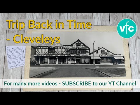
This short video of long-gone times back in the history of Cleveleys town centre brought back fond memories for many of you.
Memories of Cleveleys
Lynda Boston got in touch with some of her own recollections. She says: “This picture dates to around 1951/2. It shows my Blackpool born dad (John Hulme) with my little sister on his left and me on his right, outside the old cinema on Victoria Road West. You might be able to date it more accurately if you can pin down when that film was shown there?“

“My grandmother, Dorothy Hulme, lived in a flat at the top of the (then) Midland Bank that was on the tram track junction of Victoria Road West. We often spent happy holidays there throughout my childhood, although we really shouldn’t have been there because of bank security etc. So we had to be very quiet during working hours.
“‘Our’ bedroom looked out over the tram track and we spent hours in the evenings (when we were supposed to be asleep) just watching the trams coming and going. I loved watching the trams being turned around, or the conductor repositioning the pole to enable the tram to return from whence it came.
“We especially enjoyed ‘flipping’ the seats back at the end of journeys. The seats back then weren’t upholstered and just wooden boards. The backs could be moved to face front or back. I have to say that today’s trams are much more comfortable. I wonder if they’re still as magical to today’s children?”
Shrinking Cleveleys coastline
The Cleveleys Coastline was wider in the eighteen hundreds. Before any sea defences were built, Spring tides speeded up coastal erosion. As you can imagine it was quite alarming to the authorities and estate companies who were losing land. Some dwellings, like Fanny Hall, crumbled and fell.
Did you know? The Coast Erosion Committee found the loss of land to be three yards every year.
There was probably a settlement here in the Middle Ages, although the name of Cleveleys is probably new. Much of the land from the 1700’s belonged to the Fleetwood Hesketh family. A lot of it was sold off after their railway plans of the 1800’s became the downfall of their wealth.
Lands in Cleveleys were sold mainly to the Horrock’s family. They were textile manufacturers from Preston.
Lost Villages
The hamlet of Singleton Thorpe was reputedly to be found about a mile out into the sea off Rossall Beach at Cleveleys. The name Singleton being a derivation of ‘Shingleton’. In other words habitation in a shingly place.
During coronavirus lockdown in early 2020, we went for a walk out on the beach to explore this fascinating story –

Enjoyed this video? Why don’t you subscribe to our Visit Fylde Coast YouTube channel – make sure you don’t miss out!
In 1555 the sea surged inland and destroyed several villages, one of which was Singleton Thorpe. Legend has it that most of the inhabitants escaped and moved inland to settle at Singleton Village.
Petrified Forests
The same inundation also spelled the end of the Forest of Amounderness. Farmers still find broken branches from that surge in their fields today. The sea never retreated back to where it came from, and year on year the Fylde coast eroded. Take a look at our new Coast Watchers project if you’re interested in coastal processes.
There’s still the evidence on the beach at Cleveleys of petrified forests when the tide goes out. Low spring tides sometimes expose preserved tree trunks, once buried under the tide many years ago. Pieces of petrified forest have been radiocarbon dated to 7000 BC.
Continuing Coastal Erosion
As the years passed, coastal erosion continued at Cleveleys, speeded along with the help of local people (much like today).
The natural sea defence of sand, gravel and boulders were moved. In 1901, it was said that 6-12 carts each day were taking materials from the shore in front of Cleveleys Hydro. That was in spite of a notice displayed by the council.
On April 18th 1905 a notice by the Board of Trade was printed in the London Gazette, prohibiting this removal. It wasn’t until some years later that modern sea defences were built.
There’s a good reason why people are asked not to take beach material, sand and pebbles. They are a natural sea defence and help to protect against flooding and erosion.
Cleveleys First ‘Famous’ Shipwreck
The Abana was sailing from Liverpool to Florida, when she was caught in a storm in the Irish Sea on 22nd December 1894. She ended up drifting north to be wrecked off Little Bispham at 5pm.
At low tide on the beach just off the new sea defences at Princes Way, you can see the wooden remains of the Abana. Technically this wreck is just in the borough of Blackpool, but what’s a few yards of sand between friends!

We filmed you this video of it in summer 2020 –

Enjoyed this video? Why don’t you subscribe to our Visit Fylde Coast YouTube channel – make sure you don’t miss out!
The crew of the Abana and the lifeboat, including the ships dog, were taken to the Red Lion Inn at Bispham to recover from their ordeal. The ship’s bell and dog were given to the landlord of the Cleveleys Hotel, who’d raised the alarm. The ship’s bell now hangs in St. Andrew’s Church in Cleveleys.
Cleveleys Most Recent Shipwreck
The last in a long line of shipwrecks on the Fylde Coast was the Riverdance Ferry.

On the night of 31st January 2008 a storm blew it off the course of its Ireland to Heysham sailing. It ended up on the beach at Anchorsholme, close to where the Abana had wrecked, many years before.
Removing the ship from the beach turned into a long saga in the history of Cleveleys. The ferry was first cut up and taken away by truck. Would you believe that, with all of that beach to choose from, the ferry had managed to land right on top of the outfall pipe and crush it! Once the ship was dismantled, the pipe under the beach needed repairing.
Cleveleys Hydro
This was a big, prominent hotel. You’d have found it around where the ‘pointy roofed’ houses are today against the seafront at Anchorsholme.
In the late 1800s, the landmark Cleveleys Hydro is built on the site of the former Eryngo Lodge. Fully licensed, it was heated throughout, with hydropathic baths, an 18 hole golf course, tennis courts and a resident orchestra. It held banquets, dance and whist drives.
Why Thornton Cleveleys?
Thornton and Cleveleys are two separate places. Cleveleys is of course the place next to the sea while Thornton is slightly inland. It’s the area just off the A585 around Marsh Mill, including land towards the banks of the River Wyre.
The name comes from the railway station of the Preston and Wyre Railway. The station was ‘Thornton for Cleveleys’. Over the years the ‘for’ has been dropped, leaving us with the name we are familiar with now.
While you’re here…
Have a look at the homepage of the Visit Cleveleys website for more of the latest updates.
Love the Fylde Coast? Sign up for your weekly email newsletter. Packed full of interesting things it arrives in your inbox all 52 weeks of the year.
Join us on Facebook at our Visit Fylde Coast Facebook Group
Don’t forget to follow us on Twitter @visitFyldeCoast

We Need Your Help
We Need Your Help


Re the Nor West ice cream factory in the late 40s/early 50s Robert May says his Uncle Reg owned it. I too had a great uncle reg Davies. who was in the motor trade To my knowledge he never owned an ice cream factory and indeed it was my Father and his brother who owned it at that time. I would really like to know more about when he thinks his Uncle Reg owned it. Would be very interested to learn more from you.
I moved here in from Salford in 1965 with my Mum and Father, I worked at the Cleveleys Shoe and slipper Factory,Dorset Ave. Then as a receptionist at the Royal Hotel Cleveleys with Penny ? Does anyone remember a couple she an Australian who ran the Royal in the 60/70 I was given a beautiful aquamarine ring by her and still wear it today. The pebble bar, I also worked at night with Norma in the little coffee bar what is now the barbers on Rossall Road. The Queens, Dolphin bar. I always thought the Cleveleys Hoel was a listed building ? Such great memories I am still in the same bungalow since 1968 would not go anywhere else. Love Cleveleys.
Hi Jean, can you help me with a memory please. My Great Granddad bought a house in Cleveleys going back to about 1926 I’m told, after he died the family used the house for holidays, weekends etc. I was born in 1949 and when I was about 11 or 12 myself and my mum stayed in the house and she took me in a cafe, the thing that stood out to me was it had a Jukebox which was played a very early Elvis record and I’ve never forgot it. Did the cafe you worked in have a Jukebox? I would love to place it.
Thanks so much…Dave.
Does anyone remember North West Ice Cream factory facing the front in the 1940/50s? Mr Walker ran it
My Uncle Reg Davies owned it and always thought Eddie Cox was the manager!
Really great site thank you
Can you tell me by any chance when is their more information about the Ritherham estate or Ritherham Farm
I wonder when they allowed the housing to be built around it – i grew up around there and have so many fond memories
Does Ritherham estate still exist today i wonder
The Cleveleys Inn was at various times called Fleetwood Arms Inn – originally – in the previous century, the Wheat Sheaf (1624), and the Hesketh Arms (1660). In later years, it became “Ye Olde Cleveleys Inn Café”.
By then called the Cleveleys Hotel, and now on Garfield Road, it was sold at auction on the 29th of July 1868. The landlord was Richard Parr. Eryngo Lodge and Angersholme were both sold in the same auction.
The Cleveleys had lost its drinks licence by 1872, but still took in visitors until the early 1900s. The building briefly housed the Ruskin Studios, but it was demolished in 1936, and from 1945, it had been replaced by Mason’s Amusements. It was owned at the time of its demolition – by which time it was unlicensed – by MB Kirwan, a breeder of champion greyhounds who lived at The Towers. One of Mr Kirwan’s most famous dogs was “Champion Conn”.
A new Cleveleys Hotel was built on Ramper Road in 1868, and originally faced open fields. The first landlord was a Mr Parr, who still owned the hotel in July 1869, when the 8th battalion of the Royal Lancashire Rifle Volunteers camped in a field opposite. When the next camp was held in 1874, the volunteers camped in a different field at the rear of the hotel, whose landlord by then was Mr Hall. The host landlord in 1875 was Mr Hunt.
The Cleveleys Hotel – address now Victoria Road – was demolished in March 1984, to be replaced by WH Smith’s store, a New Look ladies’ clothes shop, and a Superdrug drug store.
i want to see easthams kitchen history in thornton cleverleys on marsh rd as a friends uncle work there called henry curwen born 1891 died 1975
Absolutely great. Thoroughly enjoyed reading about the history of our beautiful area we live in…. thank you for posting x
Glad you enjoyed it!
Very interesting read, throughly enjoyed it.
A fascinating history, really enjoyable and informative.